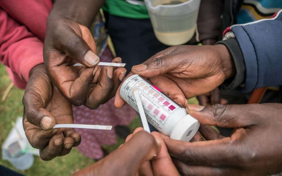
CIFOR started monitoring water levels and quality in the Sondu Basin of South-West Mau in 2014 using automatic sensors. These generated the first ever precise data set of water flow and water quality information, available continuously over two years. But now, locals...
Intrigued by the unique relationship our food crops have to their geographical environment, Lorena Gonzalez dedicated her passion for geomatic technology to collect site-specific farm data that is revolutionizing the way researchers and farmers tackle hunger.
As part of its worldwide AI for Earth program, Microsoft has recently announced grants to provide artificial intelligence (AI) technology to organizations engaged in solving environmental challenges. ICRISAT is one of the grantees and will now be able to use Microsoft...
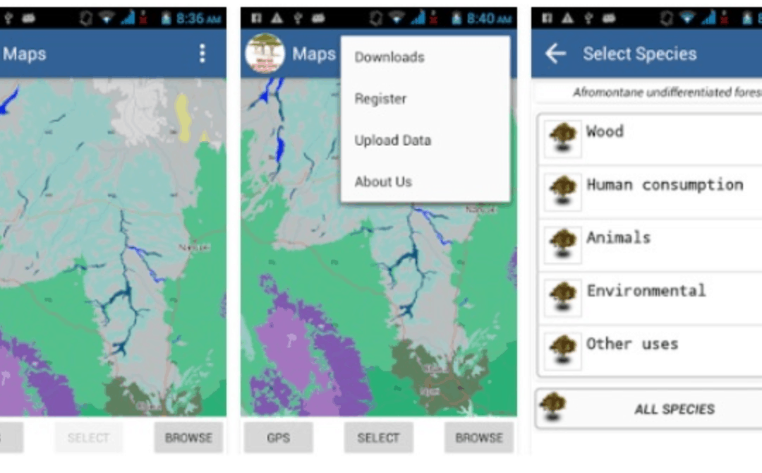
This App developed by ICRAF shows the distribution of indigenous tree species and information on the products and services that they can provide. It arms local community members, government agencies, private sector owners, and other land managers with the information...
A new mapping procedure developed by scientists at ILRI uses Demographic Health Surveys (DHS) data to bring out spatial patterns of socio-economic factors among livestock herders and systems. The map creation procedure incorporates three innovations: how the DHS data...
AgroFIMS: Your new companion for easy standardization of data collection and description
The Agronomy Field Information Management System (AgroFIMS) allows users to create fieldbooks to collect agronomic data that is already tied to a metadata standard (the CG Core Metadata Schema, aligned with the standard Dublin Core), and semantic standards like the Agronomy Ontology (AgrO), generating data that is Findable, Accessible, Interoperable, and Reusable (FAIR) at collection. AgroFIMS therefore standardizes data collection and description for easy aggregation and inter-linking across disparate datasets. The fieldbooks you create can be exported to the Android-based KDSmart data collection application, and collected data imported back to AgroFIMS for statistical analysis and reports.
In 2021 AgroFIMS will allow you to set up agronomic survey questionnaires, for data collection via ODK. It will also allow easy upload of your “born FAIR” data to Dataverse repository platforms with Dublin Core-compliant metadata schemas.
Funding for AgroFIMS was provided by the Bill and Melinda Gates Foundation’s Open Access, Open Data Initiative, and the CGIAR Platformfor Big Data in Agriculture. AgroFIMS is under GPL license.
Go to AGROFIMS →
Responsible Data Management Guidelines to protect privacy
CGIAR Platform for Big Data in Agriculture advocates open data for agricultural research for development. It considers that opening up research data for scrutiny and reuse confers significant benefits to society.
However, the Platform appreciates that not all research data can be open and that a broad range of legitimate circumstances may require data to be restricted.
As an integral component of its advocacy for open data, the Platform promotes responsible data management through the entire research data lifecycle from planning, collecting, storing, disclosing or publishing, transferring, discovery and archiving.
These guidelines were created from information collected from: review on best and emerging practices across various sectors in the fast changing landscape of privacy and ethics (130 external resources); privacy and ethic materials sourced from seven CGIAR centers; first draft was circulated for input and feedback across CGIAR and incorporated into this edition. It’s important to note that this is an evolving document, the next stage is to consult externally for further input.
These Guidelines are intended to assist agricultural researchers handle privacy and personally identifiable information (PII) in the research project data lifecycle.
Ensure consistency with the DMP-PII and the purpose for which prior informed consent has been obtained
Revaluate likelihood of (re-)identification and risk of harm, particularly if it involves a public data-set containing PII (as above)
Ensure PII is stored securely to protect privacy (as above)
Minimize use of PII and risk of disclosure through pro-privacyaccess controls and analytical tools (as above)
Don’t transfer data containing PII unless have explicit consent
Don’t transfer data containing PII in the absence of a data sharing agreement identifying aspects such as purpose and scope of use, privacy protections measures, confidentiality and any limitations)
Don’t reuse or transfer PII until any inconsistencies with the DMP-PII and/or purpose compatibility have been resolved (e.g. through updated ethics review or consent from participant)
Plan for archiving or data destruction early in the process. Destroying data can be more secure, however, archiving can be beneficial if the data has ongoing evidentiary, scientific or cultural value. If archiving, identify where and how, the budget require
Ensure DMP-PII and purpose compatibility (as above)
Ensure adequate security measures to protect privacy (as above)
Don’t wait until the end of the project to assess archiving needs when time and resources may be limited
Don’t assume the longevity of a particular format, future-proof your archives data
Don’t forget to budget for archiving data, this should be done as part of your Data Management Plan
Ensure DMP-PII and purpose compatibility (as above)
Revaluate likelihood of (re-)identification and risk of harm, particularly if it involves a public data-set containing PII
Indicate in metadata the availability of raw data or minimized data containing PII, if available bilaterally
Minimize use of PII and risk of disclosure through pro-privacyaccess controls and analytical tools
Don’t include PII in public datasets unless absolutely necessary to preserve the data’s analytic potential, scientific utility or benefit to the participant (and subject to participants informed consent and a rigorous risk assessment)
Ensure compatibility with the DMP-PII (as above) and also the purpose for which prior informed consent has been obtained
Ensure PII is stored securely to protect privacy, through organizational or project specific safeguards to prevent unauthorized access, accidental disclosure or breach of data (physical & technical)
encryption for the storage and transmission of PII
access control measures to limited access to PII
two-factor or multifactor authentication
cloud services & back-end security
Don’t store data in unsecured locations or on unsecured devices or servers
Don’t store encrypted data and encryption keys in locations where they can be easily accessed simultaneously
Don’t underestimate the importance and value of administrative safeguards to standardize practices (i.e. organizational policies, procedures and maintenance of security measures that are designed to protect private information, data and access)
De-identify data to anonymizeby default unless it will impair the data’s analytic potential, scientific utility or benefit to the participant,
If you cannot anonymize, minimize the PII and pseudonymize to reduce the disclosure risk
Provide research participants sufficient information to use reasoned judgment to decide whether or not they wish to participate in the project
Ensure informed consent is designed to address the following elements:
competence, comprehension, full disclosure, voluntariness
legitimate scientific purpose for which the PII is collected and scope of use (e.g. stored, transferred, published and whether as anonymized, minimized or raw data)
foreseeable risk of privacy loss and consequences
meaningful alternatives including opt-in protection/anonymization
safeguards to protect privacy, conditions on which PII may be shared and any limitations on reuse or third- party access and use of PII
permission to follow-up or contact the participant and for what purpose (including by third- parties)
participant’s right to withdraw and rights regarding their data (e.g. to be informed; to access; to rectify; to object; to erase)
inclusion of physical, phone and/or electronic contact (at least two forms of contact) that participant can reach to exert her/rights
explicit consent and participant’s acknowledgement of understanding
if written, provide the participant a copy of processed informed consent
Use plain language and adapt informed consent to meet the needs of vulnerable populations (e.g. obtain orally or in local language)
Don’t collect PII unless you have a Data Management Plan and any necessary approvals in place, including the recorded approval of the potential participant
Don’t collect PII unless you absolutely need it
Don’t assume that removal of direct identifiers is sufficient to anonymize data or that all de-identification techniques will result in anonymized data. Consider the risk of re-identification of a research participant, particularly if datasets are combined. If there is a reasonable risk of re-identification the information should be handled as PII (i.e. undertake risk analysis, evaluate stronger anonymization techniques, seek informed consent for the disclosure of data and explain its possible consequences)
Don’t include vulnerable participants or communities if their ability or capacity to provide voluntary informed consent is genuinely in question
Don’t underestimate the potential of quasi or indirect identifiers to identify an individual, particularly the inherent ability of location-based data to identify participants and their communities, and the increased risk of harm this may pose to potentially vulnerable individuals/communities
Avoid seeking overly broad consent that may call into question transparency or a research participant’s understanding regarding the use of their PII, be specific regarding the activities, purpose and limitations associated with PII so that the participant can make a genuinely informed decision and downstream users can evaluate purpose compatibility and seek fresh consent if needed
Develop a Data Management Plan which governs the handling of PII in the research project and beyond (DMP-PII). It should address:
the type and nature of PII
compliance requirements (including necessary forms for obtaining consent, and ethics clearance, if applicable)
legitimate research objectives that will be advanced by the PII
foreseeable risks and consequences if participants are identified from the data
privacy protection measures (or lack thereof) for collection, storage, transfer and publishing
process for obtaining informed consent
timeframe or trigger for archiving or deletion of PII
Employ stricter standards for research involving vulnerable populations such as children or illiterate participants or sensitive data such as ethnicity or religious beliefs
Undertake due-diligence of datasets previously collected by you or third parties to ensure you are entitled/permitted to use for your research project
Consult the legal, IRB or ethics clearance committee or any other relevant institutional group for specific institutional, local, regional or national policies and regulatory frameworks that may apply to PII in the context of your work
Don’t leave the handling of PII and privacy protection as an after-thought, plan ahead!
Don’t forget to checklocal laws and donor or third-party requirements in addition to institutional policies governing research ethics and privacy protection (seek expert support if unsure!)
Don’t ignore ethical practices/standards, if your institution does not have an ethics framework or clearance process in place self-assess!
In assessing whether information is capable of identifying someone (i.e. PII) don’t limit your focus to direct identifiers, also consider indirect/quasi identifiers. Appreciate this will depend on the context of the research project, the data in question and external data which is or may become otherwise available (i.e. there is no exhaustive list).
In assessing risk of harm don’t forget to consider potential harm to the participant’s community or groups of individuals that can otherwise be identified or associated with the participant