10 ways CGIAR is opening up data for agricultural innovation
Across CGIAR, researchers are working together with farmers to develop, test and deploy innovations that both generate and draw on open data.
Collecting data for farmer baseline studies using CIAT technologies. Lushoto, Tanzania. Credit: Georgina Smith / CIAT
To coincide with open access week, running from 22-28 October, we’ve compiled 10 CGIAR-led agricultural innovations that are propelling our progress towards the Sustainable Development Goals and supporting smallholder farmers from Mexico to the Philippines.
The CGIAR Platform for Big Data in Agriculture is unlocking agricultural innovation by building capacity internally and externally on big data approaches in agriculture, developing communities of practice to encourage interaction and engaging a range of actors to produce new ideas to solve development problems.
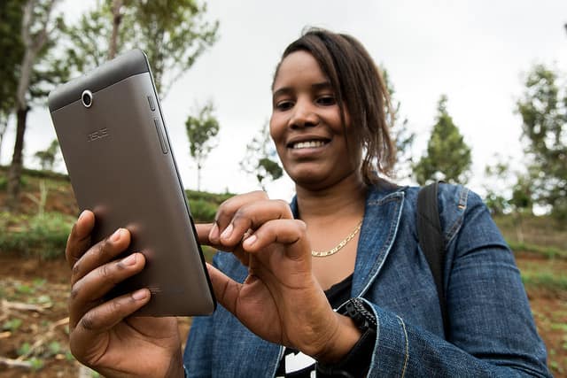
Crowdsourcing data in Kenya
When researchers from the Center for International Forestry Research (CIFOR) discovered there were no consistent data sets on the state of water resources in the Sondu-Miriu River basin in Kenya, they decided to test a novel approach – crowdsourcing data from the communities in the area. 13 water-level gauges were erected with signs that explained the project and asked passers-by to send measurements from the gauges through SMS. The data they received was cross-checked with much more expensive automatic gauging stations nearby and was found to be highly accurate.
“We are talking about open access data: data that belongs to the people, and that could be used by them to make decisions about resource use,” Lutz Breuer, Chair of Landscape, Water and Biogeochemical Cycles at the Research Centre for Biosystems, Land Use and Nutrition at Justus Liebig University Giessen in Germany told CIFOR’s Forests News blog. This low-cost approach to data collection has great potential for low-income countries.
Opening up precision agriculture through large-scale data collection
The International Maize and Wheat Improvement Center (CIMMYT) is embracing a so-called “seismic shift in agriculture” – replacing time-consuming manual data collection with technology.
Instead of walking through fields and taking measurements by hand, data can be collected from a distance through remote sensing. Using cameras mounted onboard manned and unmanned aerial vehicles, as well as through ground sensors, researchers can gather information including plant height, canopy temperature and relative biomass, and evaluate plant health and soil spatial variability in a matter of minutes rather than weeks.

A UAV is launched to collect data from a field in CIMMYT’s experiment station in Ciudad Obregón, Mexico. Photo: CIMMYT/ Peter Lowe
This site-specific information is being used to improve maize and wheat farmers’ decision-making, allowing for more precise agriculture. Providing open access to geospatial decision-support tools will allow smallholder farmers to gain the information needed to make calculated decisions on the exact quantity, location and application of resources to optimize production.
Using artificial intelligence to diagnose crop diseases
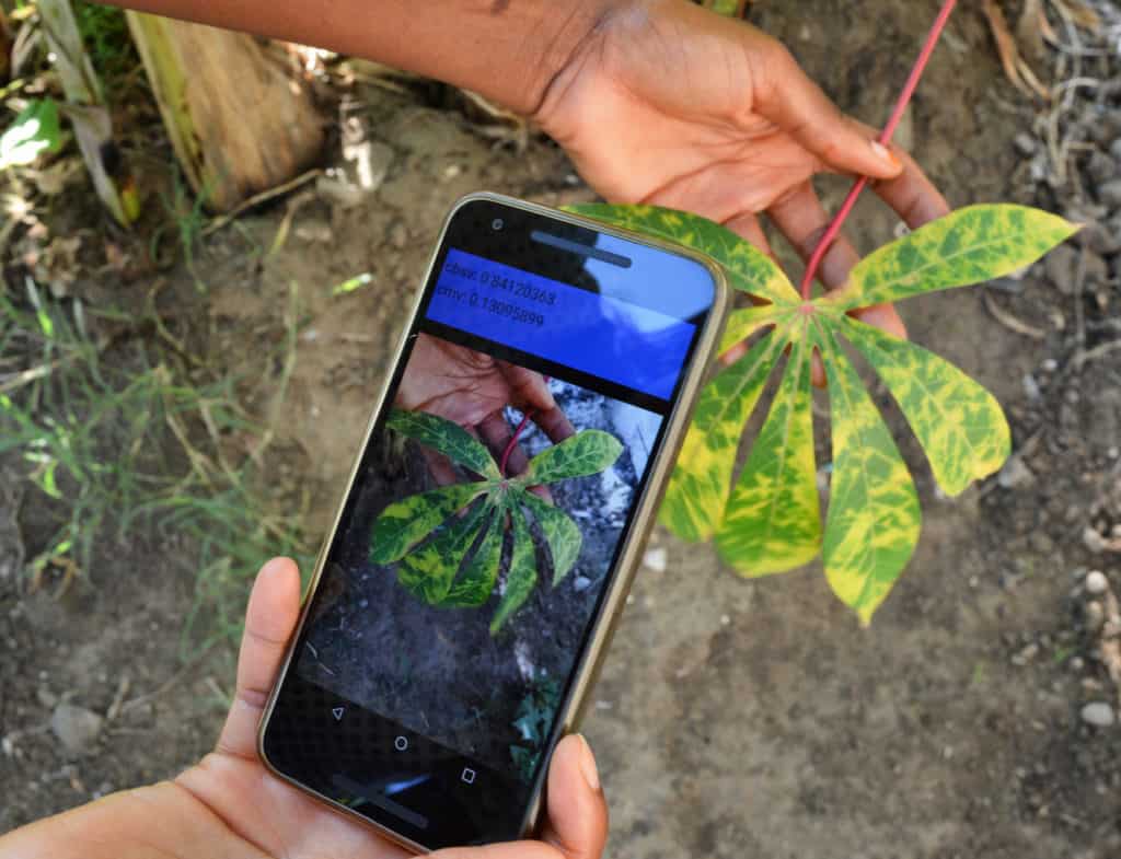
Researchers have developed a free-to-download mobile app that uses artificial intelligence and images captured on a smartphone to diagnose cassava diseases in the field. Cassava growers in Africa are affected by several pests and diseases, and early identification helps farmers to manage them and reduce crop losses.
“Of course, we can take pictures with our smartphones and send them to experts, or even better, what if we could train our smartphone to diagnose the diseases for us, from the images they capture?” explained Babuali Ahmed, a researcher from RTB implementing center, the International Institute of Tropical Agriculture (IITA). The app, called Nuru, is free to download from the Google Play store.
Zooming in on irrigation

A researcher demonstrates how he takes readings for the Geographic Information Systems and Remote Sensing. Photo: IWMI
In a study on mapping irrigated areas in South Africa’s Limpopo Province, researchers with the International Water Management Institute (IWMI), South Africa´s Department of Agriculture, Forestry and Fisheries (DAFF) and the Limpopo Department of Agriculture and Rural Development (LDARD) used satellite imagery to map irrigated and rainfed areas of Africa and Asia.
The results of the study reflected a meaningful step toward consistent, near real-time reporting on the status of irrigation, using open-source remote sensing data. Replicating the approach in other provinces could provide the basis for building a national system to assess irrigation development.
Tailoring solutions for farmers: Rice Advice mobile app
 The Africa Rice Center has launched a powerful new decision-support tool, called ‘RiceAdvice-WeedManager’ to help African rice farmers find the most effective and cost-efficient weed management strategies, matching their specific farming conditions and available resources.
The interactive tool is freely available to download from the Google Play store and can be used across rice-growing environments, from rainfed uplands to fully irrigated lowlands, leading to significant improvements in efficiency, productivity and incomes. Weeds are serious constraints to rice production in sub-Saharan Africa, with annual weed-inflicted yield losses in rice are estimated at around 2.2 million tons per year in the region, which equates to at least US$1.5 billion losses.
Speeding up wheat rust diagnosis
Sequencing pathogens using the MARPLE Mobile lab in the field near Addis Ababa. Photo: CIMMYT.
Rust diseases are a huge threat to wheat production in Africa, and more aggressive variants have adapted to warmer temperatures over the last decade. MARPLE – the Mobile and Real-time Plant desEase – is a portable testing lab for wheat rust diseases in Africa and could help speed up the identification and targeting.
The suitcase-sized lab was developed by the Saunders lab of the John Innes Center, in collaboration with the Ethiopian Institute of Agricultural Research and CIMMYT. The lab can be incorporated into early warning systems, and result in more effective control of disease outbreaks.
Mapping the risks posed by crop pests
Insect pests cause major yield losses in agricultural crops. Climate change is expected to exacerbate this impact, with warming temperatures affecting insect populations, range expansion and outbreaks. To inform the development of integrated pest management strategies, the International Potato Center (CIP) launched an online Pest Distribution and Risk Atlas for Africa.
The open-access, mobile-accessible resource combines up-to-date information on major insect threats to potato, sweet potato, vegetable and maize production with current risk maps for each pest and predictions for future climate scenarios. Researchers, agricultural ministry officials and extension agents can use that information to plan efforts that help farmers better manage crop pests now and prepare for future threats.
![]()
Using advisory apps to collect big data
Data collection can be difficult and expensive, and is often restricted to a geographic area, and may not capture key factors. Data advisory apps, however, may be a solution, utilizing crowdsourced data collection on key agronomic variables.
The Taking Maize Agronomy to Scale in Africa project has been researching the use of mobile apps, which has resulted in the CIMMYT-developed Maize-Seed-Area app. It enables farmers, agro-dealers and extension officers to measure the size of a maize field and identify its key characteristics – providing them invaluable insights to maximize plant spacing and density.

Collaborating to make CGIAR outputs open and accessible
![]() As part of a commitment by CGIAR to invest in and implement an open access and data management policy from 2013, many activities and processes have been set up to support this movement. CGSpace, an open access repository, started life as an institutional effort by the International Livestock Research Institute (ILRI) and has evolved to become the central repository for dozens of Centers and Program’s research outputs and results.
As part of a commitment by CGIAR to invest in and implement an open access and data management policy from 2013, many activities and processes have been set up to support this movement. CGSpace, an open access repository, started life as an institutional effort by the International Livestock Research Institute (ILRI) and has evolved to become the central repository for dozens of Centers and Program’s research outputs and results.
A recent article explores the origins of the CGSpace repository, the open access value proposition, technical developments, content management and standards.
Maximizing rice production with free online tools

Sukarni, a woman farmer from Pati District, Central Java. (Photo: JIRCAS/IRRI)
WeRise, a weather-rice-nutrient integrated decision support system used in rainfed rice areas of Asia, is a free online tool developed by the International Rice Research Institute, with funding from Japan. It uses a seasonal-weather forecast to give farmers crucial weather information, such as the start of the dry and wet seasons, and expected rainfall throughout the cropping season.
The tool even takes it one step further, advising farmers when to sow and transplant, what variety of rice to use, and even how much fertilizer to use. WeRise helps farmers to maximize the growing season by allowing them to produce a second rice cycle by optimizing sowing timing and enabling water to be used more efficiently.
Marianne McDade
Communications Coordinator for CGIAR Platform for Big Data in Agriculture
Cali, Colombia


Wow, fantastic…
This could be the best step to get more yield from crops…
AI is very useful to the Agriculture sector to detect diseases and recommend pesticides for that particular decease…
#From INDIA