Geospatial data
The latest news and updates from our Geospatial data community of practice.
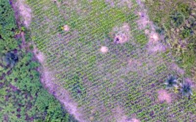
Mapping Maize using UAV Imagery
Remote sensing-based crop mapping in sub-Saharan Africa (SSA) is challenging due to the small field size, intercropping, different crop species with similar phenologies, and high cloud frequency during the growing season. Ingrid Öborn, the Southeast Asia Regional...

EGU 2018: Numerous sessions on applications of geosciences data offered
Sessions on big data theme largely addressed the current mismatch between increasing explosion of large volumes of data that outstretch the existing storage and processing capabilities.

A Note from the GEO4SDGs Conference
To fully take advantage of the vast amount of geospatial data from new sources, we should invest in ourselves on the AI and machine learning techniques, or develop a technical partnership.

Big data collaboration for crop loss research – it’s complicated
We already know we lose a vast amount of crop produce to diseases, pests, and weeds. But how do we find out how much, where, and when?
