Inspire Challenge 2017 Proposal
Tomorrow’s Rain in Africa
Across Sub-Sahelian Africa, daily atmospheric activity provides sustenance for the success of agriculture and daily life but also poses serious risks to farm productivity, citizen health, and economic stability.
Unexpected rain and temperature changes can result in spoiled food drying, fertilizer run-off, disrupted travel, and malarial shock. Consequently, daily planning is heavily dependent on access to accurate weather forecasts.
While the academic canon of African hydrometeorology runs deep, applications addressing real-time needs are lacking. Few countries in Central Africa have access to weather bulletins. Forecasts that are available are riddled with inaccuracies (previous tests have yielded accuracy rates as low as 35%).
The nature of convective systems across Central Africa is such that numerous forecast models lack the geospatial resolution to capture storm activity – and therefore accurately predict rainfall.
An idea to solve this
With the goal of supporting underserved farmers, FarmersFirst: Africa (FFA) aims to produce an actionable next-day rain forecast to help smallholder farmers effectively plan and prepare their agricultural and economic activities to build a sustainable future.
The advent of big data technologies enables an entirely automated, algorithmic method for producing weather forecasts. In partnership with Weather Analytics, FFA will develop essential weather forecasts in our pilot country, Central African Republic (CAR).
More specifically, we are building an artificial intelligence next-day rain forecast to drive better decision-making and results on and off the farm.
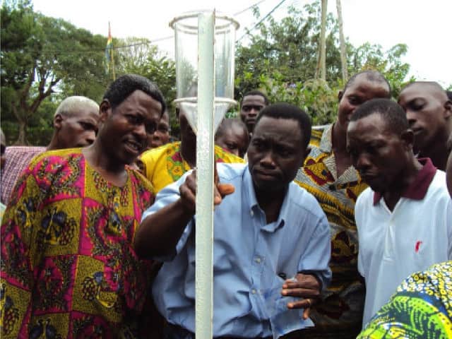
Working with local partners, we will deploy a network of up to sixty rain-gauges operated by farmers that will provide ground truth data in order to train different forecast models to improve accuracy – using a machine learning process developed by Weather Analytics.
These rain-gauges will be deployed in up to 20 villages across CAR, increasing the number of daily rainfall measuring sites in the country from 3 to 63.
Additionally, we will use the rain-gauge network to calibrate satellite observed data across the region, which will allow us to train the network even in areas where the rain-gauges are not deployed.
The goal of this work will be to produce a next day rain forecast with a >75% accuracy to be distributed via shortwave radio that can reach farmers in their native language, Sango, as well as French.
The novelty and success of our program is achieved by bringing the ‘three legs of the stool’ together:
- ground truth data that increases accuracy and involves our constituents on a daily basis,
- state-of-the-industry data science that uses the highest resolution satellite data possible for previously unattainable output, and
- medium to broadcast (via shortwave radio station) and distribute this information to ensure its usefulness, intelligibility, and ultimately, long-term adoption.
For this pilot, we will leverage state-of-the-science global forecast models from both European and American global forecast centers. We expect each weather model to have particular skill in certain regions, at certain times of the year, and for certain atmospheric conditions.
However, due to the paucity of ground station data in Central Africa, the relative strengths and weaknesses of these models have never been fully characterized in the sub-Sahelian region of Africa.
We are currently working with a shortwave radio station in Boali, CAR, to broadcast geographically limited weather forecasts.
At the same time, we are allied with several farmer co-ops and ag-focused NGOs as well as the Ministry of Agriculture; all of whom are committed to supporting distributed Internet and Communication Technology (ICT) applications.
The predicted impact
We believe that using AI in mobile phones places expert knowledge closer to the farmer much faster and at a lower cost than traditional visits on premises, and at the same time, it enables new advising services from rural extension workers.
Additionally, it can scale much better because it uses non-specialized and commonly available hardware such as mobile phones and tablets with a built-in visible-spectrum camera and GPS.
We aim to develop a stand-alone application that is not constrained by cloud computing availability but which can be enhanced by it if an Internet connection is available, by uploading the resulting diagnosis and images of crops for permanent storage, higher-level analytics, and better georeferenced and temporal visualization reports and maps that can aid farmers, NGOs, control agencies, and governments.
Support this Proposal
The Platform for Big Data in Agriculture is all about the creating connections to build the capacity’s need to inspire real change in the agriculture sector.
The aim of the Inspire Challenge is to generate innovative ideas that will revolutionize the future of agriculture using big data tools. You can be a part of the revolution by supporting these initiatives and help secure food for the future.
Contact one of the team members below to ask how you can help realize this idea.
Team:
Emmett Soldati | Email
Program Director (Farmers First Africa)
Partners:
![]()
