Mapping Rice Yields using Synthetic Aperture Radar (SAR) and the ORYZA Model

used in this study which involved (i) LAI values classification and grouping yield simulation
inputs into unique combinations, (ii) yield simulation run using Rice-YES and ORYZA, and (iii) mapping rice yield results using MAPscape-RICE. (Figure 5)
Abstract
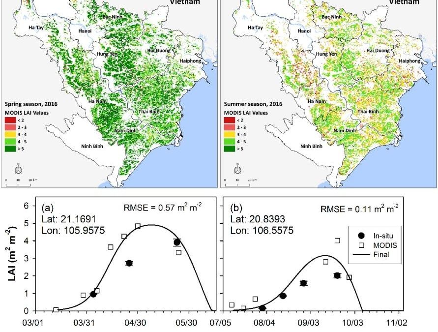
A rice yield estimation system was developed based on the crop growth model ORYZA and SAR-derived key information such as start of season (SOS) and leaf area growth rate. Results from study sites in South and South-east Asian countries suggest that incorporating remote sensing data, specifically Synthetic aperture radar (SAR), into a process-based crop model improves the spatial distribution of yield estimates.
This article highlights the detailed methodology of SAR data incorporation into crop yield simulation and comprehensive validation of yield forecast and estimates in the Philippines, Vietnam, Cambodia, Thailand, and Tamil Nadu, India. Remote sensing data assimilation into a crop model effectively captures the responses of rice crops to environmental conditions over large spatial coverage, which otherwise is practically impossible to achieve. A process-based crop simulation model is used in the system to ensure that climate information is captured, and this provides the capacity to deliver a mid-season yield forecast for national planning and policy for rice.
Good agreement between SAR-based yield and crop-cut-based yield and official yield statistics and ensuring efficiency of the processing suggest that the system is a promising solution for the needed timely information on rice yield for application in food security and policies, climate disaster management, and crop insurance programs.
Setiyono, T. D., E. D. Quicho, F. H. Holecz, N. I. Khan, G. Romuga, A. Maunahan, C. Garcia et al. “Rice yield estimation using synthetic aperture radar (SAR) and the ORYZA crop growth model: development and application of the system in South and South-east Asian countries.” International Journal of Remote Sensing 40, no. 21 (2019): 8093-8124.
September 20, 2019
CGIAR-CSI

