Mapping the Potential of Flood-based Farming using Satellite Remote Sensing

Ground survey data locations in Afar regions during meher season.
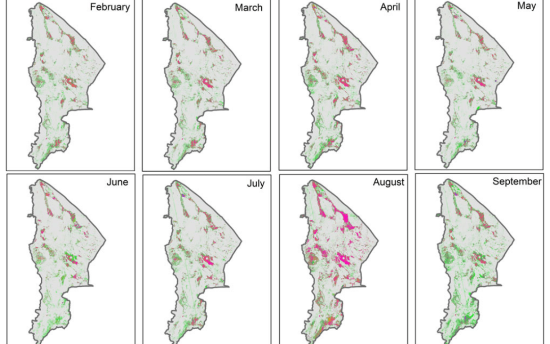
To map the intensity of flood potential, the team first mapped land use land cover (LULC) using Landsat-8 and MODIS data. Secondly, they extracted the slope map from SRTM DEM and integrated with LULC and categorized slope wise LULC areas for the study region. Third, they mapped monthly flooded areas for belg and meher seasons, integrated with temporal maps for each month, and classified it into four classes. The maximum possible flooded areas were integrated with slope classes and generated maps along with statistics for the districts in the Afar region in Ethiopia. This method show the potential for effectively identifying the flood potential of regions or basins to guide strategic planning of flood-based development in Afar and similar areas.
Abstract
The dry lowlands of Ethiopia are seasonally affected by long periods of low rainfall and, coinciding with rainfall in the Amhara highlands, floodwaters which flow onto the lowlands resulting in damage to landscapes and settlements. In an attempt to convert water from storm generated floods into productive use, this study proposes a methodology using remote sensing data and geographical information system tools to identify potential sites where flood spreading weirs may be installed and farming systems developed which produce food and fodder for poor rural communities. First, land use land cover maps for the study area were developed using Landsat-8 and MODIS temporal data. Sentinel-1 data at 10 and 20 m resolution on a 12-day basis were then used to determine flood-prone areas. Slope and drainage maps were derived from Shuttle RADAR Topography Mission Digital Elevation Model at 90 m spatial resolution. Accuracy assessment using ground survey data showed that overall accuracies (correctness) of the land use/land cover classes were 86% with kappa 0.82. Coinciding with rainfall in the uplands, March and April are the months with flood events in the short growing season (belg) and June, July and August have flood events during the major (meher) season. In the Afar region, there is potentially >0.55 m ha land available for development using seasonal floodwaters from belg or meher seasons. During the four years of monitoring (2015–2018), a minimum of 142,000 and 172,000 ha of land were flooded in the belg and meher seasons, respectively. The dominant flooded areas were found in slope classes of <2% with spatial coverage varying across the districts. We concluded that Afar has a huge potential for flood-based technology implementation and recommend further investigation into the investments needed to support new socio-economic opportunities and implications for the local agro-pastoral communities.
Gumma, Murali Krishna, Tilahun Amede, Mezegebu Getnet, Bhavani Pinjarla, Pranay Panjala, Gizachew Legesse, Gebeyaw Tilahun et al. “Assessing potential locations for flood-based farming using satellite imagery: a case study of Afar region, Ethiopia.” Renewable Agriculture and Food Systems (2019): 1-15.
March 19, 2020
CGIAR-CSI

