“We Fly! What’s Next?”

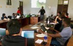

After three days of the intensive hands-on training workshop, “Drones for Agriculture”, co-organized with WeRobotics and Tanzania Flying Lab on August 20-22, 2018, in Zanzibar, Tanzania, ten trainees from five CGIAR Centers (ICRISAT, IFPRI, ICRAF, CIMMYT, and IITA) and three partner institutes sat together to discuss our community’s next steps to help mainstream the use of drones in CGIAR’s research.
All trainees shared the excitement on the potential of using drones in many different ways, especially in the area where we directly interact with smallholder farmers with small plots and complex land use. Satellite-captured imagery is still (and will be) useful for the large-scale research, but they often pose the challenges in the resolution and cloud contaminations. Whereas, drones can be immediately deployed to measure the status of farming in a (near-)real-time and provide useful insights right away. During the workshop, we used the Pix4Dfields software to mosaic all the imagery files and make them ready for analysis within minutes. If not by farmers themselves, we imagined the potential use-cases where extension agents (together with CGIAR, of course) fly drones in the area they cover, identify the areas of potential issues and provide support as needed (note: we are not the first one to think about this). There were also many cases we could easily see the future of smallholders’ agriculture incorporating drone-captured data.
Adding to the potential, there were few topics the group wanted to point out:
- Standardization: There are many options for the choice of drones, and different choices across CGIAR may pose a challenge to the interoperability of drone-captured imagery from different centers. Should we come up with some form of standard?
- Algorithms: Despite the potential and confirmed feasibility, currently there is no easy way to derive agriculture-relevant information from the imagery, such as the height of crops, size of canopy, detection of phenological stages, and delineation of field boundaries. For this, we agreed to closely collaborate and communicate with the developers of drone image processing tools.
- Cost implications: In addition to the drone itself, but there are other drone-associated costs for training, maintenance, regulation compliance, insurance. Are we ready to make a firm commitment to adopt drones and manage the running cost of operation?
- Data management: Size of drone-captured data files can get very, very large. What’d be the best way to share and manage this new stream of data?
The group did not have an immediate answer to each of the topics, but all agreed this discussion was an important beginning. More discussion will follow in the coming months to keep the momentum and realize the potentials.
Finally, there was a broad consensus on one thing, calling for an (in)action: Let’s stop buying drones at the Centers. As noted above, there are so many challenges beyond the purchasing of drones, and we, as a group of researchers, are not best positioned to address them. Instead, we discussed the best course of action to incorporate drones in our research would be through the technical partnerships, where the partner takes care of the operation and we analyze the data. For this, we appreciated WeRobotics’ continued effort to establish regional/national Flying Labs in the developing world.
More discussion followed at the training workshop’s side event, Drones for Agriculture: Knowledge Sharing Day. Stay tuned!
September 4, 2018
CGIAR-CSI

